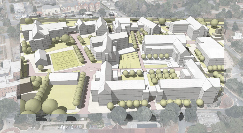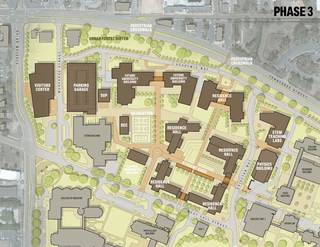
The plan reorganizes the district around a relocated Chieftan Way and a stronger pedestrian network. The existing roadway divided the science precinct from the residential district and created conflicts among pedestrians, service vehicles, parking entrances, and deliveries. Moving the roadway west creates a more cohesive campus, reduces access points, and provides safer north-south connections between Call Street, Academic Way, and Tennessee Street. The proposed alignment responds to existing utilities and mature live oaks while relocating science-building service access away from primary pedestrian routes.
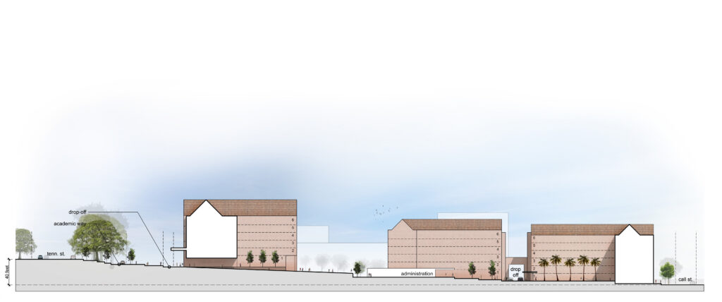
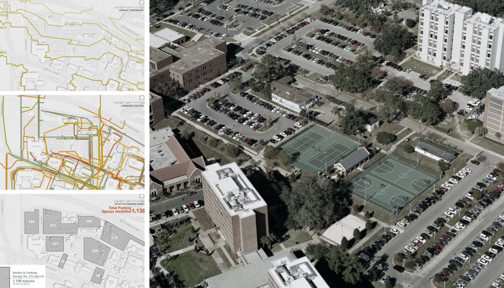
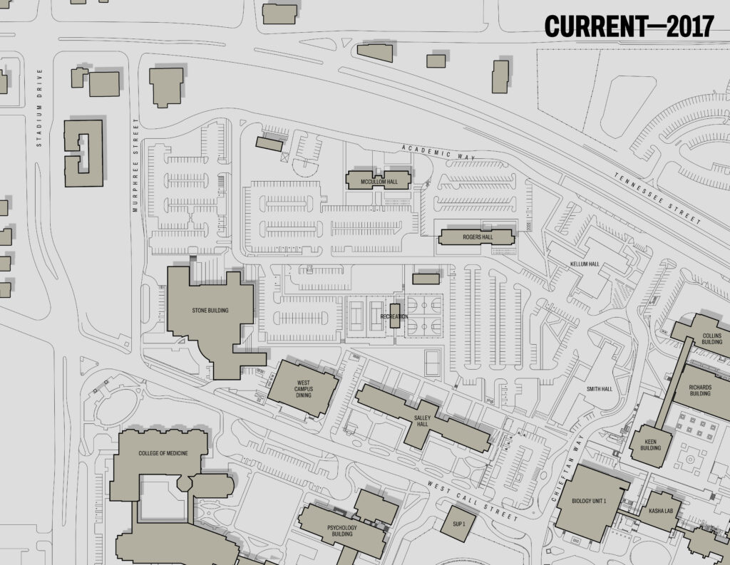
Existing conditions analysis documented a district shaped by aging residence halls, science and support buildings, expansive surface parking, fragmented pedestrian routes, and competing service and vehicular movements. Approximately 1,130 parking spaces occupied 393,000 square feet of developable land, while the meandering alignment of Chieftan Way separated the residential area from the science precinct and created multiple conflict points near Biology Unit 1.
Planning also had to account for nearly 40 feet of grade change between Call Street and Tennessee Street, mature live oaks, existing utilities, a steam tunnel, and buildings requiring renovation, replacement, or removal. These conditions established the basis for determining future building sites, roadway alignments, pedestrian connections, parking consolidation, and the sequence of each development phase.
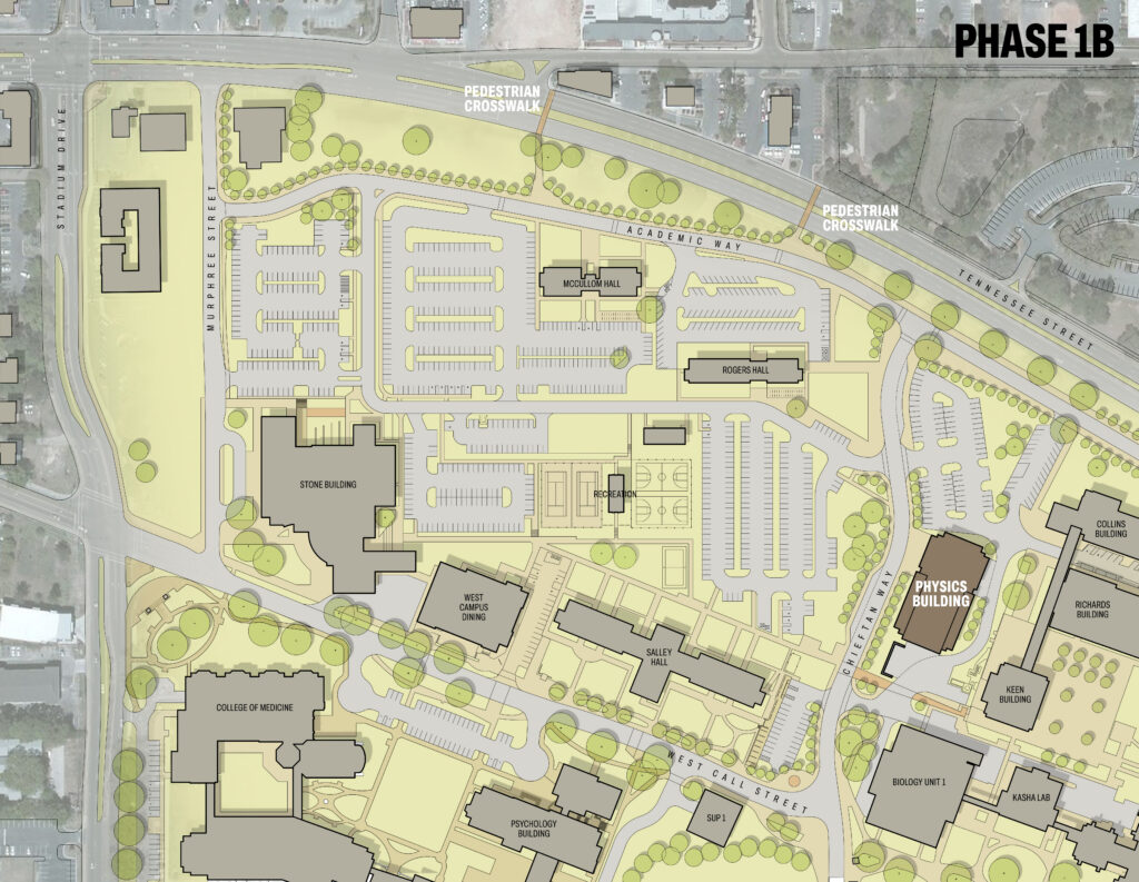
Phase One includes demolition of Smith Hall, relocation of Chieftan Way, improvements to Academic Way, and development of an approximately 125,000-square-foot STEM Teaching Laboratory Building. The planned five-story facility occupies a 25,700-square-foot footprint and establishes a prominent academic presence along the northern edge of campus. Its placement strengthens connections to the Collins, Richards, and Keen buildings while allowing service and utility access from a shared drive to the east. Renovations to Salley and McCollum residence halls extend the useful life of existing housing as the University prepares for later replacement phases.
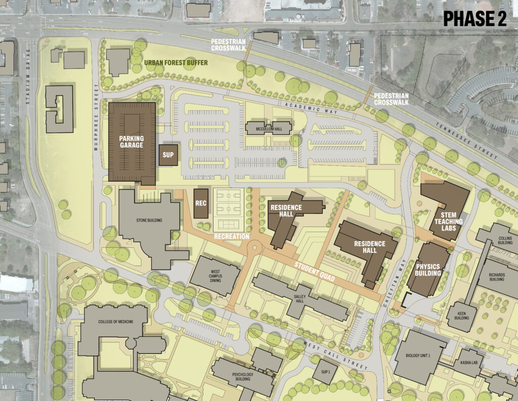
Phase Two introduces an approximately 123,000-square-foot Physics Building, two six-story residence halls, a satellite utility plant, and a reconfigured outdoor recreation area. The Physics and STEM buildings share a linear courtyard, creating a pedestrian-focused science precinct with service access concentrated along its eastern edge. The first two residence halls can accommodate as many as 825 beds combined, with a ground-floor Housing Office and an enlarged promenade designed to support everyday circulation, move-in and move-out traffic, covered drop-off, tent events, and student programming.
Parking Garage 7 consolidates parking at the northwest edge of campus and releases substantial land for future development. The proposed 1,200-space garage occupies a 56,500-square-foot footprint, approximately 14 percent of the 393,000 square feet then used by 1,130 surface parking spaces. Its location near Murphree Street and Hull Drive provides access from the campus perimeter while improving pedestrian connections to the science buildings, Stone Building, housing, and recreation areas. Relocated basketball and volleyball courts, a recreation pavilion, plazas, lawns, and outdoor fitness areas create an integrated student recreation district near the West Campus Dining Facility.
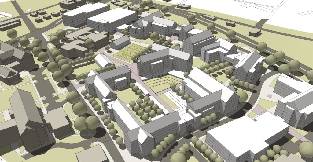
Phase Three completes the residential quadrangle with two additional six-story residence halls following the eventual removal of Salley Hall. The four residence halls define an approximately 75,000-square-foot courtyard with lawns, hardscape, shaded gathering areas, tiered seating, and controlled access for residence-hall move-in. Three additional buildings along Academic Way reinforce FSU’s presence on Tennessee Street, while a 900-foot-long North Lawn becomes the primary organizing landscape for the district. Varying from approximately 125 to 175 feet wide, the lawn uses terraces, retaining walls, seating, slopes, paths, and tree canopy to address nearly 40 feet of grade change while connecting academic buildings, housing, recreation, parking, and a potential western visitor center.
At the broader campus scale, the plan establishes a coordinated framework for directing growth toward an underutilized area with strong connections to existing academic, residential, and transportation networks. Its phased approach allows FSU to align individual capital projects with housing demand, academic priorities, parking replacement, utility capacity, and available funding while preserving continuous campus operations. New development along Tennessee Street and Stadium Drive strengthens the University’s public presence, and the North Lawn, pedestrian promenades, and relocated roadway connect the northwest district to the larger campus circulation system. Together, these recommendations provide FSU with a flexible basis for evaluating future projects and strategically expanding its campus footprint over several decades.